Vallen · Demographic and resilience profile
STATUS AT STARTEX 01.10.2028 · VALLEN SYNTHETIC POPULATION MODEL V6A reference annex for members of the Vallen Local Resilience Forum: who lives where, how the region votes and thinks, what the emergency services can field, and where its critical infrastructure is weakest.
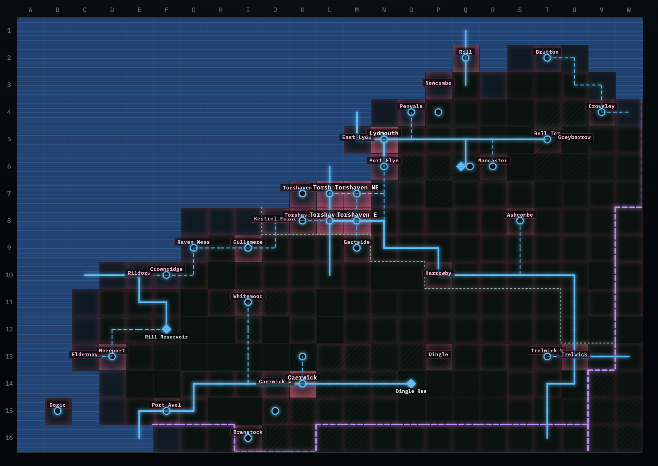
1. Population at a glance
| Count | Share | |
|---|---|---|
| Total population | 2,653,500 | — |
| Households | 1,153,700 | 2.3 persons per household |
| Adults 18+ | 2,136,000 | 80.5% |
| Working age 19–64 | 1,592,000 | 60% |
| Children 0–15 | 464,000 | 17.5% |
| Young people 16–24 | 281,000 | 10.6% |
| Aged 25–44 | 698,000 | 26.3% |
| Aged 45–64 | 690,000 | 26.0% |
| Aged 65+ | 520,000 | 19.6% |
| Disabled (Equality Act) | 504,000 | 19.0% |
| Male / female | 1,311,000 / 1,343,000 | 49.4% / 50.6% |
Vulnerable groups for planning. Over-65s, children under 16 and disabled residents add up to nearly 1.5 million. The groups overlap, so fewer individual people are involved. The over-65s are concentrated in the coastal retirement town of Penvale (25,000).
2. Where people live
Three-quarters of Vallen's people live in 26 urban grid cells, which cover a small fraction of its land.
| Settlement type | Grid cells | Population | Share |
|---|---|---|---|
| Dense urban | 6 | 1,120,000 | 42% |
| Urban | 20 | 893,000 | 34% |
| Suburban / small town | 8 | 111,000 | 4% |
| Large village and farmland | 152 | 511,000 | 19% |
| Rural settlement | 21 | 18,000 | <1% |
| Sparse rural / training area | 24 | <1,000 | — |
Terrain. Lowland 156 cells, upland and moorland 42, coast 33, sea 137.
Main settlements
| Settlement | Population | Character / notes |
|---|---|---|
| Torshaven conurbation | 870,000 | Regional capital and port city |
| — Torshaven (centre) | 300,000 | Major city, Vallen's most diverse district; Torshaven Port; Vallen Police HQ (the legacy Driftwoodshire Police HQ), Fire HQ, ambulance station |
| — Torshaven S | 250,000 | Large student population; Dunmere Tech University labs |
| — Torshaven NE | 100,000 | Marine Engineering Cluster (sabotage/espionage risk); Greater Driftwoodshire Authority (county) |
| — Torshaven E | 100,000 | Defence SMEs; Torshaven General Hospital |
| — Torshaven NW / W | 120,000 | Affluent suburbs; light industry |
| Caerwick (+ Caerwick W) | 275,000 | Second city; county council; Caerwick General Hospital; motorway bridge |
| Lydmouth (+ East Lydd) | 135,000 | Container port, naval repair yard; RNB Lydd; Defence Communications HQ; seat of the MSA |
| Port Elyn | 80,000 | Affluent leisure and surfing town; Elyn Airport nearby |
| Trelwick (+ Trelwick W) | 80,000 | Government complex, HMP Trelwick, community hospital |
| Gullemere | 60,000 | Light-industrial town |
| Rill | 58,000 | Impoverished coastal town |
| Mereport | 57,000 | Gritty industrial port; fish processing |
| Gartside | 48,000 | Gartside Logistics Park and Distribution Hub |
| Harrowby | 44,000 | Former industrial river town; council office |
| Newcombe | 39,000 | RAF Newcombe; high proportion of military families |
| Whitemoor | 35,000 | Upland light-industrial town |
| Ashcombe | 33,000 | Food processing and agricultural services |
| Port Avel | 31,000 | Fishing port; lifeboat station |
| Branstock | 31,000 | Light industry; supermarket depot |
| Kestrel Point | 30,000 | 1 GW gas power station; subsea gas landfall |
| Dingle | 30,000 | Market town, food processing |
| Crowsley | 27,000 | Crowsley Food Processing Park |
| Penvale | 25,000 | Elderly retirement town |
| Nancaster | 22,000 | Affluent county town; 800 MW gas power station |
| Bell Tor | 21,000 | Gentrified market town; bridge |
| Crownridge | 12,000 | HMG Datacentre; subsea data landfall; MOD Police post |
| Brutton, Raven Ness, Eldernay, Rilford | 2,000–6,000 each | Remote coastal villages; Raven Ness hosts the Regional Coastguard HQ |
| Doric (island) | 1,000 | Ferry from Eldernay, heliport; cut off in bad weather |
| Greybarrow | 500 | Army training area on the moor; live firing |
Social geography
- Affluent: Port Elyn, Nancaster, Bell Tor and the Torshaven NW/W suburbs. These areas are generally well connected and better able to absorb disruption.
- Deprived or post-industrial: Rill, Mereport, Harrowby and the light-industrial towns of Gullemere, Whitemoor and Branstock. They are the least able to absorb disruption and form the main audience for anti-migrant and anti-government narratives.
- Defence-dependent: Newcombe and East Lydd. These communities are directly exposed to the "NATO is the aggressor / our bases make us a target" narrative.
- Rural and agricultural: dairy, poultry, cattle and sheep farming across the east and the moorland, with large dairy units at S2 and W4. The population is dispersed, many residents are older, and the area depends on roads and fuel.
- Eastern European workforce: concentrated in the cities and in the food-processing, fish-processing and logistics towns (Mereport, Gartside, Ashcombe, Port Avel, Dingle, Crowsley), where it makes up about 1.7% of residents. It is exposed to anti-migrant narratives and is economically important to the food supply chain.
3. Ethnicity, religion and social profile
Vallen is less diverse than the UK as a whole. About 98% of residents are White, a figure that includes about 40,000 people from Eastern European communities. Minority communities are concentrated in the three cities.
| Ethnicity | Count | Share |
|---|---|---|
| White | 2,600,000 | 98.0% |
| — of which Eastern European | 40,000 | 1.5% |
| Asian | 20,000 | 0.75% |
| Black (African and Caribbean) | 13,000 | 0.5% |
| Mixed | 13,000 | 0.5% |
| Other | 7,000 | 0.25% |
| Religion | Count | Share |
|---|---|---|
| Christian | 1,377,000 | 51.9% |
| No religion | 1,099,000 | 41.4% |
| Muslim | 13,000 | 0.5% |
| Hindu and Sikh | 8,000 | 0.3% |
| Jewish, Buddhist, other | 24,000 | 0.9% |
| Not stated | 133,000 | 5.0% |
Where minority communities live
| Area | Population | Visible minorities | Muslims | Black | Hindu and Sikh | Eastern European |
|---|---|---|---|---|---|---|
| Torshaven conurbation | 870,000 | 30,300 (3.5%) | 7,600 | 7,600 | 4,500 | 21,100 |
| Caerwick | 275,000 | 9,900 (3.6%) | 2,500 | 2,500 | 1,500 | 6,900 |
| Lydmouth | 135,000 | 4,700 (3.5%) | 1,200 | 1,200 | 700 | 3,300 |
| Other towns | 780,000 | 7,100 (≈1%) | 1,800 | 1,800 | 1,000 | 7,300 |
| Villages and farmland | 590,000 | 1,000 (0.2%) | 300 | 300 | 100 | 1,100 |
- About 85% of Vallen's ethnic-minority residents live in Torshaven, Caerwick and Lydmouth. The largest concentrations are in central, south and east Torshaven, where the Muslim independents hold their council seats.
- Outside the cities, minority communities are very small, often a few dozen families in a town. This makes individual mosques, temples, shops and families highly visible, and easy targets for incitement of the kind seen in Bradford.
- Eastern European workers are the largest minority outside the cities, concentrated in food and fish processing and logistics (Mereport, Gartside, Ashcombe, Port Avel, Dingle, Crowsley).
Qualifications (aged 19–64). - Degree level (NQF4+): 50% - A-level or equivalent: 18% - GCSE or equivalent: 16% - Below GCSE or no qualifications: 16%, about 255,000 people
Income. The model divides the population into five equal income bands of about 530,000 people each. Local deprivation shows up in the settlement notes, not in the numbers.
4. Political baseline (2028 polling)
Vallen's totals match the national polling at STARTEX: Labour 35, Reform 19, Conservative 19, Liberal Democrat 10, Green 6, others 11. Turnout is assumed at 60% of adults. The vote is distributed according to the region's political geography:
| Area type | Adults | Labour | Con | Reform | Lib Dem | Green | Other* |
|---|---|---|---|---|---|---|---|
| Cities (Torshaven, Caerwick, Lydmouth) | 1,082,000 | 45% | 11% | 13% | 8% | 9% | 13% |
| Market towns (Nancaster, Bell Tor, Dingle, Ashcombe, Penvale, Port Elyn, Newcombe, Trelwick) | 266,000 | 27% | 33% | 17% | 16% | 3% | 5% |
| Ex-industrial towns (Rill, Mereport, Harrowby, Gullemere, Whitemoor, Branstock, Gartside, Crowsley, Kestrel Point, Port Avel) | 339,000 | 29% | 14% | 34% | 5% | 2% | 15% |
| Villages and farmland | 450,000 | 19% | 33% | 23% | 15% | 4% | 7% |
| Vallen | 2,136,000 | 35% | 19% | 19% | 10% | 6% | 11% |
*Other includes Restore Britain (strongest in the ex-industrial towns) and the Muslim independents in Torshaven.
Combined, Reform and Restore poll about half the vote in the ex-industrial towns, the main battleground for anti-migrant and anti-government narratives. Labour's vote is concentrated in the cities. For opinion by demographic group, see the Public Mood board.
Political tribes (More in Common segments)
Vallen's 2.19 million people aged 16 and over divide into seven political tribes. These match the Public Mood board, which shows how willing each tribe is to resist foreign aggression and how much influence it has.
| Area | Adults 16+ | Progressive Activists | Incrementalist Left | Established Liberals | Sceptical Scrollers | Rooted Patriots | Traditional Conservatives | Dissenting Disruptors |
|---|---|---|---|---|---|---|---|---|
| City core (Torshaven centre, NE and E; Caerwick; Lydmouth) | 783k | 14% | 26% | 9% | 10% | 15% | 5% | 23% |
| University district (Torshaven S) | 206k | 28% | 23% | 8% | 12% | 9% | 4% | 17% |
| Affluent suburbs (Torshaven NW and W, Caerwick W) | 120k | 11% | 24% | 23% | 5% | 15% | 11% | 11% |
| Market and coastal towns | 272k | 8% | 21% | 13% | 5% | 25% | 15% | 14% |
| Ex-industrial and port towns | 347k | 5% | 16% | 3% | 9% | 27% | 7% | 33% |
| Villages and farmland | 461k | 7% | 18% | 9% | 6% | 28% | 17% | 15% |
| Vallen | 2,189k | 11% | 21% | 9% | 8% | 20% | 9% | 20% |
- Dissenting Disruptors (about 447,000) are concentrated in the ex-industrial towns, where they make up a third of adults, and in the poorer parts of the city core. They are the main audience for anti-migrant and anti-NATO narratives.
- Rooted Patriots and Traditional Conservatives dominate the market towns and villages. They are patriotic and trust authority, but are sensitive to fuel, food and community disruption.
- Progressive Activists cluster around Dunmere Tech University in Torshaven S. Established Liberals are concentrated in the affluent suburbs.
- Sceptical Scrollers (about 179,000) are spread across the city and the ex-industrial towns, and they get their news mainly from social media.
5. Emergency services and response workforce
The establishment figures come from the model; the "available at STARTEX" figures apply the Turn 1 effectiveness ratings.
| Service | Establishment | Effectiveness | Available at STARTEX (approx.) | Main bases |
|---|---|---|---|---|
| Police (Vallen Police) | 6,029 | 90% | 5,400 | Vallen Police HQ, Torshaven (the legacy Driftwoodshire Police HQ); stations at Lydmouth, Caerwick, Trelwick, Harrowby, Gullemere, Ashcombe, Port Elyn; MOD Police at Crownridge |
| Fire | 1,624 | 80% | 1,300 | Torshaven Fire HQ; Lydmouth, Caerwick, Trelwick, Harrowby, Gullemere |
| Ambulance | 1,046 | 95% | 990 | Only three stations: Torshaven, Lydmouth, Caerwick |
| Coastguard | 546 | 95% | 520 | Regional HQ at Raven Ness; lifeboat at Port Avel |
Defence and reserves
| Count | Concentration | |
|---|---|---|
| Regular military | 7,694 | RAF Newcombe (≈2,000), Torshaven, Caerwick, Greybarrow, Lydmouth |
| Active reservists | 1,297 | Spread with population |
| Strategic reservists | 9,000 | Held on a secure database (Scenario briefing). Former regulars lean to the countryside and garrison towns: villages and farmland ≈2,600, market and coastal towns ≈1,600 (Newcombe ≈340), ex-industrial towns ≈1,500, city cores ≈2,550, Torshaven S only ≈250 |
Repair and restoration workforce
| Count | |
|---|---|
| Energy | 4,085 |
| Telecoms | 1,961 |
| Water | 1,469 |
About half of each workforce is concentrated in Torshaven, Caerwick and Lydmouth.
Hospitals. There are three: Torshaven General, Caerwick General and Trelwick Community. There is no acute hospital in the north-east (Newcombe, Penvale, Crowsley), in the far west (Mereport, Rill) or on Doric.
6. Critical infrastructure and known weaknesses
Energy (≈2.4 GW installed)
| Site | Type | Capacity | Location |
|---|---|---|---|
| Kestrel Point | Gas | 1,000 MW | J8, at the subsea gas landfall |
| Nancaster | Gas | 800 MW | R6 |
| Dingle Hydro | Hydro | 265 MW | O14, at Dingle Reservoir |
| Offshore wind | Wind | 100 MW | B9, power cable landing at Raven Ness |
| Mereshaven and Caerwick EfW | Energy from waste | 2 × 30 MW | D12, K13 |
| Solar farms (13 sites) | Solar | ≈220 MW | Dispersed; output low in winter |
Weaknesses - Kestrel Point supplies about 40% of Vallen's generation and sits at the end of a single subsea gas pipeline. Gas plants supply about three-quarters of capacity, and both depend on gas supply. - In winter, solar contributes little, so Vallen relies on two gas plants and the hydro.
Subsea links and landfalls
| Link | Route | Weakness |
|---|---|---|
| Data cable | Lands at Crownridge | Co-located with the HMG Datacentre. This is the cable dragged in September |
| Gas pipeline | Lands at Kestrel Point | Co-located with the 1 GW station |
| Power cables | Offshore wind to Raven Ness; Doric link | The Raven Ness landfall shares a cell with the Regional Coastguard HQ |
Water
There are three reservoirs: Nancaster, Rill and Dingle. Nancaster is flagged for sabotage and flood risk, and Dingle also feeds the hydro station. Treatment works serve most towns, with trunk mains running across the rural east and west.
Transport chokepoints
- The motorway suspension bridge at N8 is the region's main transport interchange, linking Torshaven, Lydmouth and the motorway network.
- There are road bridges in Torshaven centre and Torshaven E, Caerwick (motorway), Trelwick, S10 and Bell Tor.
- Ports: Torshaven, Lydmouth Container Port, Port Elyn and RNB Lydd, plus fishing harbours at Mereport, Port Avel, Rill and Eldernay, and Doric Harbour.
- Airfields: Elyn Airport (civil), RAF Newcombe and Doric Heliport.
Fuel
- AvGas depot at RAF Newcombe (flagged for sabotage and kinetic attack)
- Naval fuel depot at East Lydd
- Maritime fuel depot at Torshaven Port
- Otherwise, petrol stations only in the towns. Rural areas have few forecourts.
Food
- Gartside Distribution Hub is the region's main logistics node.
- Supermarket depots are at Port Elyn, Nancaster, Torshaven NW, Gullemere, Trelwick W and Branstock.
- Food processing is at Crowsley, Ashcombe and Dingle; fish processing at Mereport.
- Households hold five days' stocks (Scenario briefing).
Government and command
| Node | Location |
|---|---|
| Mayoral Strategic Authority (Vallen) | East Lydd, co-located with Lydmouth Defence Communications HQ |
| Vallen Police HQ (legacy Driftwoodshire Police HQ) | Torshaven centre |
| Greater Driftwoodshire Authority (county) | Torshaven NE |
| Caerwickshire County Council (county) | Caerwick |
| Trelwick Government Complex | Trelwick |
| Council offices | Harrowby, Doric |
| HMP Trelwick | Trelwick |
High-risk sites in the model's hazard notes
- RAF Newcombe and its AvGas depot
- Greybarrow Training Area (live firing; sabotage risk)
- Torshaven NE Marine Engineering Cluster (espionage)
- Nancaster Reservoir
- Rilford Cliffs (coastal erosion)
- Doric (isolation in bad weather)
- Six road bridges, including the N8 motorway suspension bridge
7. Commonly understood regional challenges
- Concentration. Most of the people, services and repair crews are packed into the Torshaven–Lydmouth corridor. One disruption at the N8 interchange or a Torshaven bridge affects most of the region's response capacity at once.
- Co-location. Several high-value targets share a site:
- the MSA with Defence Communications HQ at East Lydd;
- the HMG Datacentre with the data landfall at Crownridge;
- Coastguard HQ with the power landfall at Raven Ness;
- the 1 GW station with the gas landfall at Kestrel Point.
- Thin cover outside the cities. With three ambulance stations, three hospitals, and the fire service at 80%, response in the north-east, the far west and on Doric is slow.
- Social exposure. Retirement and rural communities are vulnerable to energy and fuel disruption. Deprived ex-industrial towns are the most receptive to disinformation, and defence towns are exposed to the "bases make us a target" narrative. Minority communities are small and highly visible: about 13,000 Muslims, most of them in central Torshaven, and about 40,000 Eastern European workers, many in the food-processing towns. Both are obvious targets for incitement.